Photos by Jack A. Waldron

Located within the Roman province of Phrygia Pacitiana, Laodikeia on the river Lycus (a mere 5 kilometers from Hieropolis/Pamukkale), located in the Hellenistic regions of Caria and Lydia, is also recorded as one of the seven churches of the Apocalypse in Revelations of the New Testament. In modern times, it might be appreciated more as testament to the troubles in Syria, the Syria Gate (pictured above), partly so named as an entrance point of world trade, the silk road, and the goods delivered through these gates from lands afar, including Syria, which at the time reached far into modern Turkey. As pictured above, what remains of the Syrian Gate today (built between 81-96 AD) are the scattered remains of its Corinthian capitals, triglyphs, architraves, and so on.

The Syrian Gate is situated at the head of Syrian Street, which sits some 600 meters outside the East Byzantine Gate, where between which must have contained a busy area, yet today lay open field that awaits excavation, unless this area was reserved in accent times for the cultivation of crops within the city walls for times of siege?

With the East Byzantine Gate pictured in the foreground above, the white cloud situated on the distant slope to the right of the full tower pictured is Pamukkale/Hieropolis, while in the distance to the left of the tower are the remains of Church of Laodikeia, which is amongst the earliest of remains of a christian church known, and which introduced groundbreaking architectural features that would lead to the great domed cathedrals of later antiquity. Interestingly, the modern protective structure somewhat re-reprepresents the original structure, most likely with intention.

The East Byzantine Gate was built shortly after 395-396 AD by the order of the emperors. It sits along Syria Street some three hundred yards closer to the city than the Syrian Gate, and is incorporated into a defensive wall that encircled the city. The East Byzantine Gate is flanked by two towers that collapsed from an earthquake during the early 7C AD, and connected to the right tower is the Byzantine Nymphaeum.

The grand scale of the city, and the central role that Syria Street plays in the function of the city is on full display once inside the East Byzantine Gate. Syria Street stretches nearly one kilometer, from the Syrian gate to just beyond its crossing of Stadium Street.

The engineering workings of Syria Street itself is a not that far removed from a typical street in modern Rome today. The earlier Hellenistic constructions were modified and expanded upon in later times, often as the result of repairs made due to earthquake damage, or, simply for functionality.

Founded during the Hellenistic period, most of what remains today are from the later Roman period. The city of Laodikeia was name after Laodike, the wife of its founder, commander Seleucus Antiochus II. The city was designed according to the Hippodamian grid plan, on which streets cross at right angles and/or run parallel to each other.

The city prospered most between the 1C-5C AD, and most of the building were constructed during this period. The total reach of the ancient city is about 5 kilometers, an expanse that is hardly possible to cover in any meaningful way in only one day, especially under the sizzling sun of summer!!

As mentioned above, Laodikeia became such a prominant city due to its location on the crossroads of commerce. Its most dominant trade was in textiles, followed by marble, grain and livestock. As I cycle the surrounding area of Laodikeia, it becomes abundantly clear that marble was and still is a massive industry, as marble quarries are everywhere to be found (and further, the trucks hauling the massive marble blocks do NOT slowdown for cyclist!! They just scare the wits out of you with blow of their horn when impeding your hind quarter . . . ).

Continuing along Syria Street and just inside the East Byzantine Gate to the right of the street is a city block containing what is known as House A (pictured in the right of the photo above, with Temple A in the far distance).

This grand scale Hellenistic planned house complex incorporated street shops, several entrances, three peristyle courtyards, forty-seven rooms including kitchens, dining halls, bedrooms and so on (pictured below). At the junction of the west alley of House A is the Street Water Distribution Center.

Just up Syria Street across what is being called Temple A East Street sits the Temple A complex (pictured below). Temple A was built in the second half of the 2C AD, and encompasses approximately 58,000 square meters. The temple was dedicated to Apollo, Artimis, Aphrodite and the imperial cult.

Temple A and the portico complex was destroyed by an earthquake around 494 AD, from hence it became a quarry for the construction of other buildings. For this reason, few of the naos architectural blocks or portico blocks remain.


Inscribed in Greek on the stairway banisters of the demos (public assembly) and the boule (advisory council) are honors to Diocletian and Maximian. The banisters (as with the temple, were built of travertine blocks and faced with marble) once supported statues. As christianity spread in the 4-5C AD, the temple became an archive for the church.

The Naos of this prostyle temple in the Corinthian order is built on a high platform at the north end of the complex. The vaulted chamber (pictured below, me standing on a glass platform over the vaulted chamber) once stored gifts to the temple, and later served as an archive to the christian church.


Pictured above and below, columns lie in situ in the sub-chamber of Temple A with the engravings that reveal the period in which they were meant to reflect and inspire.


Continuing along Syria Street brings us to the Septimius Severus Nymphaeum (pictured below), which is located on the north side of the street. This is just one of the many fountains and water access points throughout the city.


Built in the late 2C and early 3C AD, the two-tiered columned monumental Septimius Severus Nymphaeum was adorned on the East and West corners with statues of lions, sat on a podium of three steps, was built of travertine blocks with a polychrome veneer and was still in use until its collapse as a result of the earthquake of 494 AD.

Sitting behind a high wall almost directly behind the Septimius Serevus Nymphaeum is the Club House of the Greens (pictured through this opening on the left side of the nymphaeum, the other side of the back wall; I missed it!!)

The Septimius Severus Nymphaeum pictured above, with Temple A in the background. Pictured below, a map shows the location of the monuments and structures along Syria Street, and the intersection with Stadium Stadium Street.

The Central Agora is located on the south side of Syria Street, across from Septimius Severus Nymphaeum, and was build during the Roman Imperial period, with the portico columns set on reused bases. In the center of the agora was a monument on a square base. Connected to the Central Agora on the south side are the Central Baths.


At the crossroads of Syria Street and Stadium Street sits the monumental Caracalla Nymphaeum (pictured below), with its gladiatorial reliefs, held two semi-circular fountains situated in a large square basin surrounded by a colonnade on two sides.


Gladiatorial reliefs decorate a niche of the fountain on the Syria Street side (pictured below). The fountain was a two-tiered structure built on a grand scale.

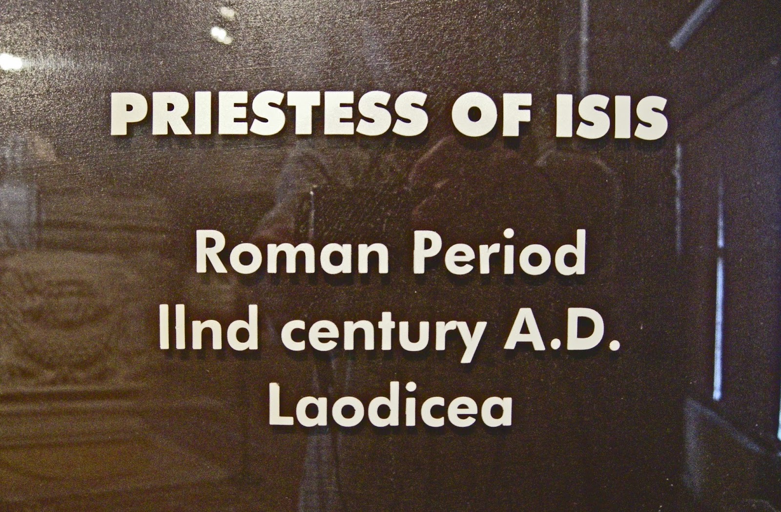
Further, the monumental Caracalla Nymphaeum was decorated with elaborate friezes and life-size statues, including this one of Isis (pictured below), which was uncovered during excavations of the nymphaeum and is now housed in the Hieropolis Bathes Museum.


Full city blocks/streets (pictured below) are under excavation, with porticoes and their pillars, shops, fountains, sewage systems, and so on, being exposed daily. More than half of Laodikeia has yet to be excavated.


Turning south onto Stadium Street from Syria Street and continuing along to the Ephesus Street crossing brings us to the Nymphaeum B complex, including Nymphaeum B (pictured below, looking from south looking north), the quaint Apsidal Fountain (picture of the rear at upper center right of photo below, at the back left corner of Nymphaeum B), the Water Reservoir (in the right of the picture below, at the back of Nymphaeum B, behind the Apsidal Fountain), and the Public Latrine (not in photo, but to the right of what is pictured below).


The Apsidal Fountain (pictured below, with the Water Reservoir/Tank behind) appears to have been in use until the 17C AD, and was most likely built due to the collapse of Nymphaeum B as the result of the earthquake of 494 AD.

Pictured below, the Public Latrine on the east side of Stadium Street, which is located next to Nymphaeum B (not pictured, but to the left of the photo below) at the Ephesus Street crossing.


Looking west up Ephesus Street from the Stadium Street crossing one enters the Ephesus Street Portico (pictured below, entrance sits opposite Nymphaeum B at the crossroads). In the forefront of the picture are the bases that supported a triple-arched gateway to the Ephesus Street Portico.


Walking east along Ephesus Street in the opposite direction from the Ephesus Portico to get to Temple A, where upon reaching Temple A Street I turned south toward the east end of the stadium. As I approached the Stadium, situated on the west side of Temple A Street is the South Agora, a huge complex consisting of the Bouleuterion on the north side of the agora, the Gymnasium on the south side, which is followed by the South Baths, and finally the Stadium, which is among the largest of the ancient world.


In the picture above, the South Agora is in the left of the photo, while scattered remains of Bouleuterion building dot the hill in the distant right of the photo, including seating blocks and ornamental marble pieces (pictured below).

Pictured below, a closer look at the Bouleuterion seating.

With the Bouleuterion at the top of the illustration below, it sits on the north side of the agora, while opposite the Bouleuterion are entrances to the Gymnasium.

The arches in the photo below are part of the South Baths complex, while the gymnasium sits before it at the edge of the agora (pictured in the foreground).


Red clay pipes can be seen within the walls of the Water Distribution Terminal 1 (pictured below).


Finally, looking west out over the Stadium from the South Baths complex (pictured below). The stadium was built around 79 AD, and could hold around 25,000 spectators.


Looking east from the west end of the stadium, the South Baths can be seen next to the stadium in the top left of the photo above. The stadium is in poor condition, partly due to earthquake damage, and some quarrying. It remains to be excavated and restored, and perhaps its grandness will show after receiving the attention it deserves.


Now back on Stadium Street facing north (pictured above and below), the white travertine pools of Pamukkale (some ten kilometers away) can be seen in the center/center left of the photos.

I now headed back toward the city center and to the monuments on the opposite side of the city, namely, the two theaters, the North Agora and so on.

With the white travertine pools of Pamukkale visible in the distance, the crumbling rows of the West Theater came into view. Built in the Hellenistic tradition, the theater could hold around 8,000 people.


Pictured below, five columns from the North Agora rise in the distance above the upper rows of the West Theater.

As I walked from the West Theater toward the North Agora and North Theater, I began to get a whiff of something pungent, and yet pleasantly satisfying. I slowing came to recognize the smell, and looking down at the ground, at the spot pictured above just outside the North Agora, I saw that I was standing in a field of eruca sativa, rucola, rucoli, rugula, colewart, arugula, roquette, SALAD ROCKET!! Fantasic! Dinner! I picked as much as I could under the sweltering sun, and gather enough for the nights dinner, and the next morning breakfast (see photo at bottom).

The area of the North (Sacred) Agora covers 265x128m, and sits between Syria Street and the street that runs between the two theaters. The North Agora housed two temples, a Corinthian temple to Athena, and an Ionic temple to Zeus.


This monumental structure was surrounded by porticoes on all sides, with pools running nearly the full length of the inner court. Pictured above, piles of hundreds of thousands of roof tiles that once covered the North Agora porticoes. Pictured below, a closer look at the massive Corinthian columns of a North Agora portico.

Just beyond the North Agora sits the North Theater. It too has been quarried over the centuries, and though massive, its days of magnificence have passed.


The North Theater was built in the 2C AD, and could hold around 12,000 people. It faces out over the Lykos plain toward Hieropolis and Pamukkale, which can be seen in the top left corner of the photo below.

Turning back toward Syria Street, we pass one of the oldest standing Christian structures in the world, the Church of Laodikeia.


The city of Laodikeia has Necropolis' on all sides of the city, and sarcophagi such as the one pictured below are numerous, though perhaps most are not as exquisitely ornamented as this one. This sarcophagus is known as the Sarcophagus with Garlands, and is from Laodikeia (currently housed in the Hieropolis Museum).

Rocket!! With with Pesti alla Genovese!! I stayed at the Denizli Oretmenevi (Oretmenevi means, Teachers' House), and payed $13 per night (breakfast included!!), but I still almost always cook my own dinner . . . , I'm saving for my Oceanis 45! I figure, I'll cycle around the world between 50-60 years old, and sail around the world between 60-70!!

*All photos and content property of Jack A. Waldron (photos may not be used without written permission)
**If you'd like to help with future postings, please feel free to support them through PATREON:
No comments:
Post a Comment
Note: Only a member of this blog may post a comment.